
RUSSIAN JOURNAL OF EARTH SCIENCES, VOL. 19, ES6011, doi:10.2205/2019ES000673, 2019
V. I. Osipov, N. A. Rumyantseva, O. N. Eremina
Sergeev Institute of Environmental Geoscience RAS, Moscow, Russia
The paper scrutinizes the role of internal geodynamics of Earth, technogenesis and global climate changes in the context of aggravating hazardous natural processes on the Earth. Intensification of geohazards due to a number of techno-natural factors requires the elaboration of a new strategy of modern civilization development based on keeping the balance between the human economic activity and the environment protection. The strategy of living with natural disasters based on the assessment of natural risks of socio-economic losses is discussed. The procedure of natural risk assessment is exemplified by the map of complex individual natural risk for population of the Russian Federation with the account of earthquakes, floods, hurricanes, snow avalanches, landslides, and mudflows. The necessity of developing the scientifically grounded policy of human technogenic activity based on the principle of technogenesis-environment coevolution is reported.
Various processes developing inside the Earth, on its surface, and in the adjacent atmosphere layers, cause manifestation of hazardous geological phenomena. The range of developing natural hazards is very wide, varying from disastrous earthquakes to the global climate warming and the hazard of Earth colliding with other cosmic bodies. Natural disasters in the modern world appear to be the source of severe social shocks causing large-scale suffering of people and fatalities and leading to huge economic losses. In the general problem of social security, natural disasters are more and more often considered as one of the principal destabilizing factors preventing sustainable development and causing great damage to the economy and the environment.
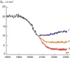
|
| Figure 1 |
The number of natural disasters grew sharply in the second half of the XX century. Above 8 million people were killed by natural disasters in the last century [Porfir'ev, 2015]. According to the data of the Centre for Research on the Epidemiology of Disasters (CRED), the annual number of natural disasters over 35 years (1980–2015) increased almost threefold (Figure 1). According to the UN, over the past 20 years, there were 7056 natural disasters in the world, in which 1.35 million people were killed and 4.2 billion people were injured [Delovaya Gazeta, 2016]. In 2017, 335 natural disasters affected over 95.6 million people, killing an additional 9,697 and costing a total of 335 billion USD (EM-DAT, http://www.emdat.be, accessed 1.07.2019). Some countries (Japan) spend up to 5% (8% at the most) of the annual budget for the elimination of natural disaster consequences. In Russia, the economic losses from natural disasters with the consideration of indirect damages reach 2% of the gross domestic product.
The cases of the most disastrous catastrophes that occurred in Russia in the second half of the XX and in the beginning of the XXI century are the Caspian Sea level rise and flooding its shores in 1978–1995, which caused the damage equal to 6 billion USD; the Sakhalin earthquake (May, 1995) destroyed completely the Neftegorsk city, and resulted in more than 2000 fatalities, and the damage higher than 200 million USD. The mean perennial losses from floods and wildfires in Russia amount to hundreds of millions USD. The flood in the Far East was the most disastrous, with its total damage having amounted to 258 billion RUR [Porfir'ev, 2015].
The spectrum of natural disasters is exceptionally large – from seismic phenomena to widely occurring floods, droughts, slope processes (landslides, mudflows, avalanches), storms, hurricanes, karst collapses, sinkholes, erosion, abrasion, etc. An increase in the number of natural and technogenous disasters is caused by the global processes operating in the social, natural and technogenic spheres. These include the growth of population and industrial production in the world, urbanization, environment degradation, and the global climate warming. In general, we may state that the rapid growth in the number of dangerous natural processes is due mainly to three global processes: (1) internal geodynamics of Earth, (2) development of technogenesis, and (3) climate change.
 |
| Table 1 |
V. I. Vernadsky wrote, "Earth cannot be regarded only as the area of matter, it is the region of energy." [Vernadsky, 1944]. Internal geodynamics of Earth is associated with processes developing in its crust and upper mantle, which cause changes in the stress state of the outer shell of Earth and the development of deformation processes. The latter is manifested in tectonics and seismicity of Earth. The greatest danger is associated with seismic processes that can develop rapidly and unexpectedly, be accompanied by release of a large amount of energy, and lead, as a rule, to major disasters on Earth's surface. There have been exceptional, in terms of energy and social consequences, earthquakes in the history of Earth. Damages from the largest earthquakes are comparable to the most destructive wars. Analysis of the available data indicates that in the second half of the 20th century, the number of large earthquakes on Earth increased significantly (EM-DAT, http://www.emdat.be). The reasons for the growth of seismic phenomena are not yet completely understood. Perhaps they are associated with a new phase of Earth's endogenic processes intensification. Technogenesis may affect the development of so-called induced earthquakes. Some data suggest that construction of dams with a height of more than 140 m, in 21% of cases, leads to induced seismic phenomena with magnitudes in the range 5–6. The impact of underground nuclear explosions on induced seismicity has also been recognized. The most destructive seismic events of the recent years (1999–2015) and the social and economic consequences caused by them are presented in Table 1.
Seismic phenomena are associated with a number of major disasters that represent a global threat. Among such accidents, for example, is the destruction of the Fukushima nuclear power plant in Japan. The station seismic design was appropriate for the maximum magnitude 7 earthquake. The accident occurred on 11 March 2011, after a magnitude 9 earthquake. The earthquake caused a 14-m high tsunami, which greatly exceeded the permissible height of 6 m in the project design. The tsunami wave flooded four out of the six station's blocks, disabling the reactor cooling system. This led to a series of hydrogen explosions, fires, melting of the core, release of radioactive substances into the atmosphere, and the death of more than 20 thousand people. No less terrible tragedy happened in December 2004. A magnitude 9 earthquake that occurred in the Indian Ocean caused huge tsunami waves that reached the coasts of Indonesia and a number of other coastal states. More than 165 thousand people of these countries died. The largest seismic event in the 21st century was the Wenchuan earthquake in China on 12 May 2008 (magnitude 10).
The technogenic activity of a man and atmospheric emissions from industrial works, transport, energy-production facilities and social infrastructure contaminate the atmosphere with fine particles and greenhouse gases. Above 32 million tons of emissions from stationary and mobile sources enter annually the Earth's atmosphere. The atmosphere in the industrial cities is being contaminated most intensely. During the last 200 years (1800–2010), the total emission of carbon dioxide (tons per year) from all sources has risen on the Earth from 280 to 390 fractions per 1 mln air fraction; it may reach 800 fractions to the end of the XXI century. The methane concentration rose from 0.8 to 1.65 in the same time period, and nitrogen oxide from 285 to 310 fractions per 1 million air fractions [Yablokov et al., 2015].
Processing of mineral resources and accumulation of waste rock in tailing dumps, heaps, and mine takes results in formation of extensive geochemical anomalies of heavy metals, carbon, nitrogen, sulfur, and iodine. The use of mineral fertilizers increases the content of cadmium, arsenic, copper, lead, mercury, and zinc in soils and millions of tons of soluble salts enter soils annually due to irrigation and reclamation of irrigation water. In addition to atmospheric pollution, technogenesis leads to intense pollution of surface and groundwater and accumulation of industrial waste. According to the latest data from the Federal Center for Subsoil Resources Monitoring [The state report..., 2014], the volume of polluted sewage discharge in Russia is about 43 billion m$^3$ yr$^{-1}$. As a result, almost half of the surface and more than one-quarter of the groundwater sources do not meet the quality standards. There are 6439 groundwater contamination sites, including 3441 of water intakes for drinking and household purposes. Besides chemical pollution, there is also anthropogenic physical pollution of the atmosphere, including growing density of electromagnetic and ionizing radiation fields, as well as light and thermal pollution. Sources of such pollution are television, radar-location, high and ultrahigh-frequency currents, and cellular and radio communication.
 |
| Figure 2 |
Apart from environment pollution, technogenic activity of a man triggers the growth of hazardous geological processes. Such phenomena include: karst collapse, flooding, and slope processes (landslides, mudflows, etc.). Dangerous technogenic processes can be of a significant scale and pose a serious threat to people and infrastructure. Figure 2 shows the Berezniki industrial region (Russia) karst collapse that occurred in July of 2008. The development of potassium salt deposits in this region by large-volume underground workings (up to 80 million m$^3$) had weakened the massifs of salt and overburden layers and reduced their density due to the hydrodynamic and geochemical impact of groundwater, which led to deformations, destruction, and flooding of the excavation sites. This was the reason for the development of the karst process and the extensive collapse. The collapse was 300x400 m wide, 80 m deep, and with a volume of 8.6 million m$^3$.
The risk of further development of catastrophic geological phenomena in the residential areas of Berezniki, located above the mine workings, is being assessed. One of the response options considered is the relocation of Berezniki to a safer territory.
Among the factors that cause intensification of natural processes, an important role belongs to global warming. The observed temperature rise is accompanied by dangerous natural processes such as drought, acid rain, melting of Arctic ice, degradation of permafrost, and intensification of geological and especially of hydrometeorological catastrophic phenomena. In 1991–2010, their number increased 3.5-fold. In 2015 alone, more than 30 large-scale droughts and catastrophic floods were recorded worldwide, with 98.6 million people affected (https://emdat.be).
A major flood occurred in 1998 on the Yangtze River, which became the most devastating in the history of China – 223 million people were impacted and economic damage amounted to 36 billion USD.
Among the extreme hydrological events that occurred in recent years in Russia are the spring flood on the Lena River in Yakutia in 2001, the flood in the Krasnodar Territory in June 2012, and the flood in the Far East in 2013. The latter is considered particularly devastating – 235 settlements were flooded in 37 districts of the Far East; 678 thousand ha of agricultural land, 430 km of automobile roads, and 71 bridges were destroyed or flooded; 135 thousand people were affected. The total damage amounted to 258 billion rubles (approx., 4 billion USD) [Porfir'ev, 2015].
In Russia, in June 2019 a devastating flood in the Irkutsk oblast affected 20 settlements in three regions. According to the latest news on the web, 2392 houses with 6000 people living there have been flooded.
Abrupt climate change events have caused intense growth of catastrophic meteorological phenomena, such as extreme heat and forest fires in Europe and the European part of Russia in 2010 and an unusually cold winter of 2012.
 |
| Figure 3 |
The role of technogenesis in climate warming is particularly evident in the Arctic region and the degradation of permafrost. A. M. Obukhov Institute of Atmospheric Physics RAS carried out a model assessment of the degradation of permafrost under global climate change; the assessment considered the anthropogenic impact. According to the calculations, the total area of near-surface permafrost soils of the Northern Hemisphere in the 21st century may decrease from 20 million km$^2$ to 5.3–12.8 million km$^2$, depending on anthropogenic impact scenario (Figure 3) [Mokhov and Yeliseyev, 2012].
The reduction of the cryolithozone area is caused by the thawing of near-surface frozen soils in the northern regions of the central part of Russia, Western Siberia, and North America. Under the most severe anthropogenic impact scenario, some parts of Eastern Siberia may be affected by the degradation also. In the persistent permafrost regions, the depth of seasonal thawing may increase. Thus, in Eastern Siberia, it may increase from 2.0–2.5 m (under the moderate anthropogenic impact scenario) to 2.5–3.0 m (under the harsh scenario).
Air pollution of the Arctic is causing intense melting of polar ice. For example, the emissions of the Norilsk Combine (Russia), whose main pollutant – the aluminum plant, was recently closed, were registered at the North Pole. The area of pack-ice in the Arctic has shrunk to half of its size over the past half century. This process is uneven and most clearly manifested in the zone of influence of the Gulf Stream warm current and is practically silent in Eastern Alaska and Northern Greenland. The process of glacier shrinkage in the Arctic is not less intensive. A forecast assessment of the state of the Russian Arctic archipelagoes glaciation over the next decades shows that the deficit in the mass balance of glaciers will increase in the current century. Especially high specific mass losses should be expected on the glaciers of Franz Josef Land and Novaya Zemlya.
 |
| Figure 4 |
The transition of soils from frozen to thawed conditions leads to deformations of Earth's surface and the development of dangerous natural phenomena in vast areas of Western and Eastern Siberia. The most important destabilizing factor in this region is thawing of soils in the area of distribution of ice deposits, polygonal vein ice or ice wedges, and sheeted ice. This process in the continental part of the Arctic enhances thermokarst, thermoerosion, solifluction, seasonal heaving, and the subsidence of Earth's surface. The most significant changes should be expected in the regions of soils and rock strata with large ice volume. These territories include the Yamal Peninsula, where the largest Bovanenkovo gas condensate field is located; there, ice sheets with an average thickness of 8 m were encountered (the maximum thickness is 28.5 m) (Figure 4). The area of some ice inclusions reaches 10 km$^2$, and the volume – more than 4 million m$^3$.
 |
| Figure 5 |
The widely occurring processes associated with permafrost degradation include thermokarst. The mechanism of formation of karst sinkholes (lakes) is usually the result of the collapse of the roof of rocks that overlap cavities (voids) arising in the frozen strata due to local thawing of buried ice or ice-saturated soils. The severity of thermokarst in the northern regions of Western Siberia is extremely high (Figure 5).
 |
| Figure 6 |
Recently, another thermokarst formation mechanism, i.e., pneumatic or explosive, has been discovered in the north of Western Siberia. Thus, in July of 2014, a deep crater that resembled an explosion funnel and filled with water at the bottom, was found 30 km south of the Bovanenkovo oil and gas condensate field in the southwestern part of the Yamal Peninsula [Bogoyavlensky, 2014] (Figure 6).
The funnel has a rounded shape with a diameter on the surface of about 60 m and a depth of more than 50 m. It is surrounded by a bank made of earth ejected to a distance of up to 120 m. The general appearance of the funnel indicates that it was formed as a result of a powerful release of gas from a shallow subterranean deposit formed, possibly, as a result of thawing of buried ice (stratified, vein or bulgunyakh nucleus – hydrolaccolithes) and the accumulation of gas. The accumulated gas in the cavity could be syngenetic (of biochemical origin) or catagenetic, migrating from deeper horizons through deep-seated faults. Its formation may be also the result of dissociation (decomposition) of gas hydrates when thermobaric conditions change.
The described gas-explosive funnel is not the only example in the Arctic zone. Other similar formations were found in Yamal and in the mouth of the Yenisei River. The latter funnel, "The Taymyr Funnel," has a a depth of about 60 m.
Explosive degassing of the cryosphere also occurs on the Arctic shelf where a submarine permanently frozen layer is present. This is evidenced by deep craters on the seabed of the shelf zone. Explosive methane emissions pose a great danger for boreholes, underwater pipelines, and vessels. In the latter case, a vessel can rapidly sink, since the density of water in the methane emission zone is reduced by half, and the vessel cannot remain afloat. There have been four tragic events leading to the total destruction or severe consequences for ships and their crews [Vinogradov et al., 2016].
Human-induced and natural disasters on Earth cause huge social and material losses. According to the Centre for Research on the Epidemiology of Disasters (CRED) (http://www/emdat.be), a significant part of the total annual damage (from 15 to 55%) is associated with seismic phenomena. Floods, waterlogging, droughts, landslides, mudslides, avalanches, and other dangerous phenomena also contribute significantly to the total damages. Seismic events are associated with the largest number of deaths in world catastrophes (about 57% of the total), followed by floods, storms, and geological hazards. Floods cause the most damage (up to 56% of the total), followed by droughts, earthquakes, and geological hazards.
 |
| Figure 7 |
The total annual socio-economic damage from all kinds of catastrophic phenomena on Earth in 1980–2015 varied from 120 billion USD to 350 billion USD (Figure 7), gradually increasing with time. The annual global damage peaked in 2011 at 350 billion USD. In subsequent years, the damage was somewhat lower. However, at the Third World Conference on Disaster Risk Reduction, held in Sendai, Japan in March of 2015, where 170 countries participated, UN Secretary-General Ban Ki-moon stated that the annual global damage from natural disasters will increase to 350 billion USD in the coming years; by 2030, it could rise to
360 billion USD (Sendai Framework for Disaster Risk Reduction 2015–2030, United Nations, 2015. https://www.unisdr.org/files/43291_sendaiframewo rkfordrren.pdf).
Some countries, for example Japan, spend as much as 5% (and even 8%) of their annual budget to address the consequences of natural disasters. In Russia, direct and indirect damage from natural disasters is approaching 2% of GDP (160 billion rubles).
The irreversible growth of the number of hazardous events causes the necessity to adopt a new strategy of struggle against natural and technogenic catastrophes based on the risk assessment and elaboration of methods of mitigating their consequences. Implementation of this strategy will permit us to pass to the economic planning and development with the account of existing hazards, to increase safety of the society, to reduce social and economic losses. The strategy should be based on "the global prevention culture" proceeding from the scientific prediction of the future disasters. It is better to prevent the disastrous phenomena rather than to eliminate its consequences. The international experience proves that the expenses for prediction and providing readiness to the emergencies are up to 15 times lower than the prevented damage.
The development of methods of predicting disasters based on deterministic and probabilistic approaches appears to be one of the most important item in this strategy. These approaches take into account the vulnerability of the technosphere, and permit predicting possible social and economic losses as well as assessing risks. Risk maps appear to be the most important document for elaborating of strategic plans on the timely engineering protection in order to minimize the consequences of future catastrophes. Risk assessment proceeds from the following main ideas and definitions [Osipov et al., 2017].
Natural risk is the probabilistic value of possible damage (social and economic) from hazardous natural phenomena in specific areas. Natural risk is a function of the probability of natural hazards occurring in the territory under consideration and the vulnerability of objects under risk located in this territory. The objects under risk are considered to be all objects to which the concept of damage may be applied.
Natural hazard [H] is estimated as the probability of occurrence of a dangerous process of a certain intensity in a given territory at a given time. Therefore, natural hazard is estimated as the probability of occurrence of a process, of a certain intensity per unit area per unit time.
Vulnerability [V(I)] is a function linking the loss of properties by objects under risk and the strength (intensity) of a hazardous natural process. Risk [R] can be estimated from the values of H and V(I) as follows:
\begin{eqnarray*} \mathrm{ R = H \times V(I)} \end{eqnarray*} |
| Figure 8 |
Thus, risk assessment includes superimposing information layers on natural hazards and vulnerability of certain areas and obtaining integrated information as the product of the two variables. In practice, this is reduced to the procedure of compiling a forecast map of the frequency of development of a dangerous process for the study area and overlaying this map over a map on settlements and objects of the technosphere, with concurrent assessment of their conditions (vulnerability) and urbanization characteristics (Figure 8). The resultant risk map identifies territories and settlements with different probabilities of individual death and injury or possible material damage within a specified period of time.
This procedure is used to target a number of tasks and assess the existing risks. The end result is the spatio-temporal probabilistic-deterministic forecast of the consequences of various natural risks, expressed as the estimated probability of an individual or integral damage (death and injury to people), as well as of losses in the social and material sectors [Larionov and Frolova, 2005].
 |
| Figure 9 |
Russia has accumulated considerable experience in compiling natural risk maps. There are risk maps of the most probable and destructive natural hazards (e.g., seismic or multi-hazard – seismic, landslide, flood, karst, etc.) for the entire country, individual regions, and municipalities. Institute of Environmental Geoscience RAS (IEG RAS) is involved in the research on compiling the risk maps for many years. In collaboration with the Extreme Situations Research Center, we have compiled more than 30 risk maps for the country as a whole and its separate regions and cities [Osipov et al., 2011, 2017]. The special GIS created for this purposes is widely used for compilation of these maps. The maps of individual natural risk, which are built both for particular hazard types and for integral hazard produced by several hazardous phenomena, are the maps of most widespread type. For the Russia territory, three maps of the integral natural risk were built to a scale of 20,000,000 USD, showing the risk produced by 6 hazard, i.e., earthquakes, floods, storms, landslides, mudflows and snow avalanches. The first map (Re1) shows the losses with fatalities in case of the mentioned processes are realized; the second (Re2) deals with the fatalities and injuries of people, and the third map (Re3) considers both death and injuries of people as well as economic losses. For example, Figure 9 displays the integral map of individual natural risk (Re1).
The obtained estimates of individual natural risk from 6 types of natural hazards vary within the Russia's territory from negligibly small to very high values, exceeding $30 \times 10^{-5}$ for the fatality (Re1), $> 100 \times 10^{-5}$, for the fatality and injuries of different heaviness, and $> 150 \times 10^{-5}$ for fatalities, injuries and economic losses.
Human technogenic activity and the global climate warming developing on the Earth are accompanied by a sharp increase in the number of catastrophic natural phenomena causing huge social and material losses. Elaboration of the strategy for society-environment interaction is the most important task for the future generations of scientific community. The main goal of this strategy is to develop in harmony with the environment. Development of methods of disasters prediction based on deterministic and probabilistic approaches is one of the most significant elements of this strategy. Taking into account the technosphere vulnerability, this permits predicting possible social and material losses and assessing natural risks. Development of techniques for adapting to ecosystems is an important aspect of the strategy of struggle against natural disasters and mitigation of their consequences. By adapting to ecosystems we should understand not the attempts to change the latter according to the society needs, but on the contrary, adjusting the technogenic activity to the existing ecosystems. In doing so, the approved axiom should be followed: a man should not interfere with the natural processes and induce their negative development. Thus, the idea of adapting to ecosystems under the conditions of technogenesis consists in minimizing the transformation of former upon solving issues of ensuring environmental safety of the society. Inscribing our activity to ecosystem processes and the engineering protection of the created technogeneous objects appear to be the basic techniques of this idea implementation.
Bogoyavlensky, V. I. (2014) , The threat of catastrophic gas emissions from the Arctic permafrost zone. Funnels of Yamal and Taymyr, Drilling and Oil, no. 10, p. 4–8.
Delovaya Gazeta, (2016) , Guide to international business, Business Daily, no. 120/121, October–November, p. 2 (in Russian).
Larionov, V. I., N. I. Frolova (2005) , General methodology of risk assessment, Encyclop. of Safety: Construction, Industry, Ecology, vol. 1, p. 2–34, Nauka, Moscow.
Mokhov, I. I., A. V. Yeliseyev (2012) , Modeling of global climate changes in the XX–XXIII centuries under scenarios of the anthropogenic impact of RCP, DAN, 443, no. 6, p. 732–736.
Osipov, V. I., N. I. Frolova, et al. (2011) , Assessment of seismic and natural risks for the population and territory of the Russian Federation, Extreme Events and Catastrophes, Vol. 2, p. 28–48, Publishing house "Probel 2000", Moscow.
Osipov, V. I., V. I. Larionov, V. N. Burova, N. I. Frolova, S. P. Suschev (2017) , Methodology of natural risk assessment in Russia, Natural Hazards, no. 88, p. 17–41, https://doi.org/10.1007/s11069-017-2780-z.
Porfir'ev, B. N. (2015) , Economic consequences of catastrophic flood in the Far East in 2013, Vestnik RAN (Herald of RAS), no. 2, p. 30–39.
Roshydromet, (2014) , The state report "On the state and on the protection of the environment in 2013", Roshydromet, Moscow.
Vernadsky, V. I. (1944) , A few words about the noosphere, Advances in Modern Biology, 18, no. 2, p. 118–120.
Vinogradov, A. N., Yu. A. Vinogradov, S. V. Baranov, et al. (2016) , The risk factors associated with the degradation of the cryolithosphere in the Western Arctic and the problems of their geophysical monitoring, Collection of scientific works, V. Pavlenko (Editor-in-chief), p. 64–70, FCIARctic Publ., Arkhangelsk.
Yablokov, A. V., V. F. Levchenko, A. S. Kerzhentsev (2015) , Essays on biosphere. 1. There is way out: a transition to a controlled evolution of the biosphere, Philosophy & Cosmology, 14, p. 92–118.
Received 2 July 2019; accepted 30 July 2019; published 23 December 2019.

Citation: Osipov V. I., N. A. Rumyantseva, O. N. Eremina (2019), Living with risk of natural disasters, Russ. J. Earth Sci., 19, ES6011, doi:10.2205/2019ES000673.
Copyright 2019 by the Geophysical Center RAS.