Russian Journal of Earth Sciences
Vol. 6, No. 6, December 2004
Large magnetic anomalies over Russia revealed by balloon data
K. A. Nazarova1, Yu. Tsvetkov2,
J. Heirtzler3, T. Sabaka1
1Raytheon ITSS at Geodynamics Branch NASA/GSFC, Greenbelt, MD, USA
2Izmiran, Troitsk Moscow Region, RUSSIA
3NASA/GSFC, Greeenbelt, MD, USA
Contents
Abstract
A stratospheric balloon flight at 30 km altitude
measured the geomagnetic field intensity along a 6000 km track
extending from Kamchatka to near the Ural Mountains. When the CM
model was used to remove the main and external fields from the
observed data, magnetic anomalies of several 100 nT amplitude and
250 to 750 km wavelength are observed. In the eastern part of the
track these anomalies appear to be due to the bodies of up to 5 km
depth and magnetizations of 0.12 SI (0.01 cgs).
1. Introduction
Magnetic measurements by stratospheric balloons provide wavelengths
intermediate between those registered by aeromagnetic and satellite magnetic
surveys. Aeromagnetic profiles provide information about anomalies whose
shortest wavelength is comparable to the distance from the source, namely from
few hundred meters to a few kilometers. Although aeromagnetic profiles also
provide information about long wavelengths these long wavelengths are usually
discarded in making aeromagnetic maps. Large geologic structures, with
dimensions of a few hundred kilometers, cannot always be inferred from their
shorter wavelength surface expression.
On the other hand present day lithospheric models of the geomagnetic field
derived from satellite magnetic data at the altitude about 400 km do not have
resolution to show magnetic features with wavelength shorter than about 1000
kilometers. These long wavelength anomalies are considered to be caused by the
sources located in the deep crust and upper mantle both in continental and oceanic
areas.
Stratospheric balloons which fly at the altitude of about 30 km: (a) register
magnetic signal from the whole thickness of the earth's crust, (b) fill the
gap
between aeromagnetic and satellite magnetic data, (c) using vertical gradient
measurements allow reliable separation of the external and internal components of
the Earth's magnetic field, (d) provide long term coverage of hard to access
areas,
(e) allow identification of large and significant tectonic structures.
There have been relatively few geomagnetic field measurements at stratospheric
altitudes. However, in recent years, there have been several stratospheric balloon
flights by France
[Achache et al., 1991;
Cohen et al., 1986]
and Japan
[Tohyama et al., 1992].
One of the longest and most successful of these, made by Russian
scientists is reported here.
2. Balloon Magnetic Survey
|
|
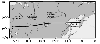
Figure 1
|
In July 1996 the total intensity of the geomagnetic field
was
measured at an altitude of approximately 30 km by a balloon flight
from Kamchatka (56.29o N, 159.75o E) on the east to the
Caspian Sea covering the Sea of Okhotsk, the Central Siberian
Platform, the West Siberian Plains and Urals Mountains (54.00o
N, 50.5o E). This 6000 km traverse was made at latitude of
about 55o N in 6 days (Figure 1). The measurements were made with a
scalar proton precession magnetometer suspended 1 km below the
gondola with accuracy about 0.2 nT. All readings were recorded
each 8 minutes, providing a complete record of 990 readings. The
altitude fluctuations were similar day by day for the whole flight.
At 5 am local time the altitude rose from 27 km to a maximum
average altitude about 33 km. It leveled off at a maximum altitude
a few hours later. In the late afternoon it fell to the lower
altitude again. Therefore for present purposes we will consider
the altitude to be a constant 30 km. No attempt was made to adjust
the magnetic readings for time variations of the geomagnetic field
strength. A typical amplitude for the diurnal variation in the
total field in 1996 in the area surveyed by the balloon was about
50 nT as observed at Novosibirsk (Klyuchi) geomagnetic observatory
located at 55oN, 82.9oE. Over a limited portion of the
track a second proton precession magnetometer was suspended 1 km
below the first magnetometer to provide measurements of the
vertical geomagnetic field gradient. Results of gradient study are
not discussed here.
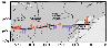
3. Aeromagnetic Survey

|
|
Figure 2
|
In 1979 the Ministry of Geology of the USSR issued aeromagnetic
anomaly maps
of geomagnetic field intensity (Z. A. Makarova, editor). These 18 maps
were
digitized by the US Naval Oceanographic Office and edited by Conoco. The
digital data is deposited at the National Geophysical Data Center (NGDC). We
analyzed digital aeromagnetic anomaly maps and came to conclusion that long
wavelength anomalies were lost during compilation when local magnetic maps were
consolidated into larger regional maps. The balloon track covers the easternmost
of these aeromagnetic maps and over the central Sea of Okhotsk aeromagnetic
data is missing (Figure 2).
4. Isolation of the Anomaly Field
Because of its altitude this survey is different from other geomagnetic field
measurements and provides unique data. It does not show the short wavelength
anomalies of near surface surveys but it does show wavelengths too short to be
included in global models of the geomagnetic field. The track is the first over land
which shows these intermediate wavelength anomalies which are common in
oceanic areas. The track of the balloon passed near one of the highs on global
maps of geomagnetic field intensity, but south of the region dominated by time
varying field aligned currents. Geomagnetic field models show long wavelength
anomalies which are thought due to the Earth's main with sources deep within the
earth. The models also show shorter wavelength anomalies ( n>14 in spherical
harmonic expansion series) which are thought to be due to crustal sources.
CM3e is a magnetic reference model able to represent not
only main and crustal magnetic fields but also the ionospheric and magnetospheric
(primary and induced) fields. A distinct magnetic low near the eastern end of the
track over the Sea of Okhotsk was observed.

|
|
Figure 3
|
Ravat et al. [[2003]
clearly showed the advantage of CM magnetic model
[Sabaka et al., 2002]
relative to IGRF in the processing of aeromagnetic data in the central
US (Kansas area). In the area of balloon track there are few ground magnetic
observatories and, since ground magnetic observatory data is integrated into the
models, there have been some difficulties with models here
in the past. Total field
maps made from the IGRF show a maximum for this region in the northern
hemisphere. Only the CM model (http://core2.gsfc.nasa.gov/CM/)
compensate for magnetic disturbances, which are part of quiet daily variations. If
one subtracts the main field components of CM3e ( n<15 ) from the observed data
one obtains the profile shown in Figure 3. For illustrative purposes the data are
also
shown with a best fit straight line removed. The same magnetic profile over the balloon
track and tectonic
|
|
Figure 4
|
structures is shown in Figure 4. Anomalies of length 5 to 15 degrees of
longitude (250 to 750 km) stand out.
5. Magnetic Modeling of Balloon Lithospheric Anomalies

|
|
Figure 5
|
To understand what crustal bodies might cause the anomalies
observed by the
balloon, we used a forward modeling technique. Since we have only a one-dimensional
survey, rather than an area survey we used a 2D modeling technique
[Heirtzler et al., 1964].
This assumes that the anomalies are linear for a length
equal to about the height of the survey (30 km). The Russian aeromagnetic survey
in other parts of Siberia suggests that this may be approximately true. For this
model study we chose the large amplitude anomaly on the eastern end of the track
covering western Kamchatka and the Sea of Okhotsk. Figure 5 shows the
observed anomaly (measured anomaly minus main field from CM3e) and the
calculated anomaly for the body shown. This body has a deep root of about 5 km
and a strong magnetization of 0.12 SI (0.01 cgs). The topographic data
show the
deep root is under the western side of Kamchatka and the root to be less deep
under the eastern side of the Sea of Okhotsk. In this calculation we assumed the
body to strike north-south, the magnetization to be induced and the inducing field
direction to be like that of the present geomagnetic field.
A preliminary checks on 2D models for other anomalies along the profile show
that there are other deep rooted bodies of high magnetization. A correlation with
major tectonic or structural features in Siberia is planned.
6. Conclusions
Magnetic measurements on a stratospheric balloon flight shows that there are
many magnetic bodies with dimensions of 250 to 750 km in Siberia. Bodies of
this
size cannot be identified with present satellite geomagnetic field models and have
not been identified from surface surveys
Acknowledgements
This project was supported by NASA\newline Headquarters code Y,
and Russian Academy of Sciences (IZMIRAN).
References
Achache, J., and C. Yves, and G. Unal (1991), The French Program of
Circumterrestrial Magnetic Surveys Using Stratospheric Balloons, EOS Transactions
of the American Geophsyical Union, 72, 97-101.
Cohen, Y., M. Menvielle, and J. L. LeMouel (1986), Magnetic Measurements
aboard a
Stratospheric Balloon, Phys. Earth Planet. Inter., 44, 348-357.
Heirtzler, J. R, G. Peter, M. Talwani, and E. G. Zurflueh (1964),
Magnetic Anomalies
Caused by Two-Dimensional Structures: Their Computation by Digital
Computers and Their Interpretation, Technical Report, no. 6, CU-6-62,
Nonr-Geology,Columbia University.
Ravat, D., T. G. Hildenbrand, and W. Roest (2003), New Way of Processing near-surface
Magnetic Data: The Utility of the Comprehensive Model of the Magnetic Field,
22(8), 784-785, The Leading Edge.
Sabaka, T. J., N. Olsen and R. A. Langel (2002), A Comprehensive Model
of the
Quiet- Time near-Earth Magnetic Field: Phase 3, Geophys. J. Int., 151,
32-68.
Tohyama, F. Y, and T. Takahashi (1992), Observation of the Geomagnetic Field
by Polar
Patrol Balloon, Journal Solar Terrestrial Environmental Research in Japan, 16,
60.
Load files for printing and local use.
This document was generated by TeXWeb
(Win32, v.1.3) on October 6, 2004.