International Journal of Geomagnetism and Aeronomy
Vol 1, No. 3, August 1999
Magnetic anomaly field of the Earth from gradient measurements at
stratospheric altitudes
Yu. P. Tsvetkov, N. M. Rotanova, V. N. Oraevskiy, A. L.
Kharitonov,
and S. D. Odintsov
Institute of Terrestrial Magnetism, Ionosphere, and Radio Wave
Propagation, Troitsk, Moscow Region, Russia
Contents
Abstract
Data on the magnetic anomaly field (MAF)
obtained from gradient measurements by stratospheric balloons and
the MAGSAT satellite are analyzed. The methods used for deriving these
fields are described, and the consistency between
the two data sets is demonstrated.
The data on MAF and its vertical
gradient have been used to construct a
lithospheric geophysical cross section that characterizes the
deposition depths of MAF sources. A detailed analysis of the
balloon flight for
j = 55 o N and
l = 81o - 121 o E
was
performed; some other geophysical parameters
were invoked for it.
By using the MAF data for different altitudes and by solving
the direct problem, it is shown that the anomalies observed in
the cross section are fairly well described by a number of
isolated sources whose magnetizations and depths do not
contradict current ideas about the magnetic field of the
Earth's crust.
Introduction
The main goals of the investigation of the
magnetic anomaly field (MAF) and
magnetically active
lithospheric
sources are directly associated with research into the
interpretation of the regional and long-wave components of the
anomalous field. Here we encounter the problem of separating
different components from the near-Earth
measurements
[Pashkevich et al., 1990].
However, at distances from the
surface of the Earth comparable with the vertical thickness of the
magnetically active lithospheric layer, the effects of the
surface and deep sources become almost equal, and a smooth field
originating from sources located throughout the layer is
observed. For instance, at stratospheric heights of ~30 km,
the MAF is represented by magnetic anomalies ranging from
regional anomalies with a transverse size of ~30 km up to those with
the longest wavelengths. If we consider the MAF as a whole,
magnetic measurements at stratospheric altitudes
successfully supplement aeromagnetic and satellite
surveys
(see, e.g., Achache et al. [1991]).
This paper analyzes the results of
magnetic
gradient
measurements at stratospheric altitudes and the MAGSAT
satellite data. The results of processing
these two experiments
are used
to determine the sources of
regional magnetic anomalies.
Observational Data and Their Processing
Three transcontinental balloon flights at heights of
H = 30  3 km along latitudinal routes
up to 5000-8000 km
in length have been performed over
Russia
[Tsvetkov, 1993].
Each of the balloons was
equipped with two proton magnetometers
whose detectors were separated by a vertical
distance of 2.5 km. The magnetometers
operated in a cyclic mode with one measurement per minute at the
average flight velocity of 40-50 km h
-1. The magnetic field was
measured synchronously by the two magnetometers, and hence the
normalized differences between these measurements
were taken to be the vertical gradient of the magnetic field.
The measurement baseline
(the distance between the magnetic field
detectors) was ~1/20 of the distance to the sources, and
hence the data obtained can only be regarded
approximately as gradient data.
In fact, the measurements are
values of the vertical gradient at stratospheric
heights averaged over a distance of 2.5 km.
3 km along latitudinal routes
up to 5000-8000 km
in length have been performed over
Russia
[Tsvetkov, 1993].
Each of the balloons was
equipped with two proton magnetometers
whose detectors were separated by a vertical
distance of 2.5 km. The magnetometers
operated in a cyclic mode with one measurement per minute at the
average flight velocity of 40-50 km h
-1. The magnetic field was
measured synchronously by the two magnetometers, and hence the
normalized differences between these measurements
were taken to be the vertical gradient of the magnetic field.
The measurement baseline
(the distance between the magnetic field
detectors) was ~1/20 of the distance to the sources, and
hence the data obtained can only be regarded
approximately as gradient data.
In fact, the measurements are
values of the vertical gradient at stratospheric
heights averaged over a distance of 2.5 km.
 The measurements of the
intensity
of the
vector
field
modulus
T and its
vertical gradient
The measurements of the
intensity
of the
vector
field
modulus
T and its
vertical gradient
 T for one of the balloon flights in
a westward direction from Kamchatka along the
j = 55 o N
T for one of the balloon flights in
a westward direction from Kamchatka along the
j = 55 o N
 parallel are shown in Figure 1. Figure 2 shows the MAF
parameters obtained from that stratospheric balloon flight.
parallel are shown in Figure 1. Figure 2 shows the MAF
parameters obtained from that stratospheric balloon flight.
During the data
processing, the normal field represented by
an analytical model and corrected for secular variation was
subtracted from the measured field. The resulting differences
were taken to be the anomalous field. An analogous procedure
was used to obtain the vertical gradient of the magnetic field.
The measuring errors have been considered by
Tsvetkov [1993],
where
the standard deviation of the MAF gradient measurements was
estimated to be 0.3 nT km
-1, with the major contribution coming
from the operating conditions of the detector on a moving
platform. The standard deviation of the MAF vertical
gradient along the whole flight length from Kamchatka to the Urals
was
s (DT)a30
= 2.2 nT km
-1,
while for the MAF itself
s (DT)a30
= 45 nT.
The root-mean-square value of the gradient for
flight path segments 600 km in length (Figure 2a) was
estimated to be in the range from 0.3 nT km
-1 (eastern and
central parts of the
Sea of Okhotsk)
to 3 nT km
-1 (the Baikal
fold system).
 The long-wave components of the MAF spectrum are also clearly
observed at satellite heights. The best observational
information for the study of the anomalous field from space is
the MAGSAT satellite data
[Cohen et al., 1986;
Langel et al., 1982].
The field
intensity at satellite heights ranges from 0 nT to 30 nT.
During the satellite data processing, only the field values
at positions corresponding
to
the above mentioned balloon flight route along the
j = 55 o N parallel were chosen in order
to find the
anomalous fields and compare them with the gradient data for
stratospheric heights. Then the data were processed to
eliminate random outliers and filtered with the critical period
of ~16 points to exclude the diurnal periodicity. From the
filtered data, only
those from intervals for which the geomagnetic
activity index of
Kp
The long-wave components of the MAF spectrum are also clearly
observed at satellite heights. The best observational
information for the study of the anomalous field from space is
the MAGSAT satellite data
[Cohen et al., 1986;
Langel et al., 1982].
The field
intensity at satellite heights ranges from 0 nT to 30 nT.
During the satellite data processing, only the field values
at positions corresponding
to
the above mentioned balloon flight route along the
j = 55 o N parallel were chosen in order
to find the
anomalous fields and compare them with the gradient data for
stratospheric heights. Then the data were processed to
eliminate random outliers and filtered with the critical period
of ~16 points to exclude the diurnal periodicity. From the
filtered data, only
those from intervals for which the geomagnetic
activity index of
Kp  2 were selected. Figure 3 shows the
anomalous magnetic field for the balloon flight route between
l = 81 o E and
l = 122 o E, where Figure 3a
illustrates the MAF at a height of 350 km (from the
MAGSAT data), and Figures 3b and 3c show the MAF and its
vertical gradient for a height of 30 km, respectively
(the balloon data).
2 were selected. Figure 3 shows the
anomalous magnetic field for the balloon flight route between
l = 81 o E and
l = 122 o E, where Figure 3a
illustrates the MAF at a height of 350 km (from the
MAGSAT data), and Figures 3b and 3c show the MAF and its
vertical gradient for a height of 30 km, respectively
(the balloon data).
Attention is drawn to the fairly good agreement between
anomalies at satellite and balloon altitudes, though some
differences are observed. This is due to the fact that the
anomalous field at the measurement point is a superposition of
the fields of sources which are mainly in the spherical
segment whose intersection with the Earth's surface is limited
by a circle with a radius nearly equal to the magnetic survey
height
[Lugovenko et al., 1990].
Therefore the anomalous field
at the measurement point at satellite altitudes is formed
by the superposition of the fields from sources within an
area approximately 100
times larger than that for a height of ~30 km.
This can explain some of the differences between the
curves shown in
Figures 3a,
3b,
and 3c.
Results
To interpret geophysically the results shown in
Figures 3a,
3b,
and 3c,
a vertical geophysical lithospheric cross section was first
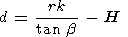
obtained. To this end, the expression determining
the MAF source depths derived from the empirical
decrease in
magnetic
anomaly
field
with
measurement height was used
[Tsvetkov et al., 1995, 1997]:
where
d is the source depth,
r is the correlation
radius of the autocorrelation function,
b is the
angle of inclination of the tangent to the curve of
anomalous field amplitude versus height of
measurements, and
k is a proportionality factor.
Figure 3d shows the variations in
this depth along the route considered. It also gives
information on some auxiliary geophysical parameters. The
question arises as to whether the constructed cross section is
reliable and consistent with other data. To this end, nearly
all the available geophysical information for the region under
study was used, and a complex analysis was performed. It
showed that the horizontal boundaries of the layers are also
the boundaries of the extent of abyssal breaks in the Earth's
crust (which is shown in Figure 3d for the
Mohorovichich
boundary), the vertical discontinuities of the horizontal
layers being more pronounced in the magnetic data. This allows
us to divide the section into blocks in both the horizontal and
vertical directions, according to geological properties.
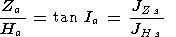
For studies of the geomagnetic field along the balloon
route, it is also important to know whether the rock magnetization
responsible for the magnetic anomalies in the region
of interest has an inductive or
a remanent
character. It is known
that the net magnetization of rocks is given by
JZs= JZr+ JZi
JHs= JHr+ JHi
where
Jr and
Ji characterize the remanent
(Jr) and inductive
(Ji) magnetizations.
By assuming that MAF is fully associated with the
magnetization of the lithosphere, we can write
where
Za is a vertical component of MAF, and
Ha is a horizontal component of MAF,
or
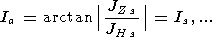
Thus if the anomalous inclinations ( Ia ) calculated from the
above expressions differ in sign from the inclination of the
current main magnetic field of the Earth which
varies
appreciably
in time and space, we can assume a predominantly remanent
magnetization.
Using the above
equations, the directions of the net magnetization vectors
along the balloon flight route were calculated from the MAGSAT
data. It turned out that for the region of the Baikal anomaly
of electric conductivity
[Rokityanskiy, 1975]
which is located
between
l = 102 o E and
l = 113 o E, the inclination
Is coincides in sign with the direction of the main magnetic
field
vector. This indicates that inductive magnetization
dominates in this region. As to the remaining part of the
profile, the values of
Is are opposite in sign to the
direction of the main field vector inclination. This suggests
that remanent magnetization dominates.
Using observational data for different heights and
techniques for solving the direct problem, the
depths of the magnetic sources were determined. The
relatively simple shape of the MAF curves for stratospheric
altitudes allows us to find the strangest anomalies and interpret them
one at a time. To minimize the
non-uniqueness
of the
set of models for the field sources,
the magnetic field distribution for
individual sources was found,
and a wide range of initial parameters (source depth,
magnetic moment) was used to eliminate the discrepancy between
the calculated field and the field measured along the flight
route. As the field model, the analytical expression for the
two-dimensional problem
[Kolyubakin and Lapina, 1960]
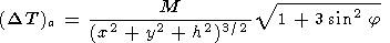 |
was used. Here
M is the magnetic moment of an
individual source,
x and
y are the Cartesian
coordinates with respect to an
origin at distance
h above the source, and
j is the
magnetic latitude. According to the superposition concept,
horizontal magnetized strata and horizontal and vertical
prismatic bodies were represented by different combinations of
different sources. To limit the number of choices, the individual
sources were correlated with the geometries of
anomalies at the Earth's surface. The direct problem was solved
separately for anomalies 1-4 shown in Figure 3b and for the
low-frequency trend of 1, 2 and 3, 4.
The parameters defining the theoretical magnetic field
were the depths of the sources, their
magnetic moments associated with the rock magnetization
intensity, and the geometrical distribution of
individual sources
corresponding to the anomalous magnetization area. The choice
was considered to be optional when the theoretical and
observed parameters, that is, the intensities and vertical gradients
of the magnetic
field anomalies
and the
extent of the anomalies at the level of
half the maximum intensity of the anomaly, coincided
simultaneously. It turned out that in choosing the optimum
models, the discrepancy between the model and measured fields
could be successfully corrected by the function of the MAF vertical gradient
which points to its high significance.
The shapes of the magnetic source bodies were determined
from the spatial distribution of such simulating sources. The
vertical sizes of these sources were estimated from the
magnetization of rocks typical of this region. In
other words, the evaluation of the source vertical thickness
required to create the calculated magnetic moment was carried
out. The magnetic anomalies shown in Figure 3 have sources in
the form of horizontal plates (strata) with a minimum width
of ~20 km and a thickness of several kilometers. The
characteristic depths of the magnetic centers of these sources
are 5, 15-20, and 30-35 km, which does not contradict
current ideas about anomalous field sources. Thus our
analysis of the MAF stratospheric observations shows that the
sources of the regional magnetic anomalies can occur at any
depth limited by the upper and lower edges of the magnetoactive
lithospheric layer. Consequently, the classification of the
anomalies in terms of source depths is not physically
justified.
Conclusions
1. Profiles of the anomalous magnetic field and its
vertical gradient have been obtained by processing
the stratospheric geomagnetic measurements and MAGSAT
satellite data for the flight route along the
j = 55 o N
parallel. The analysis and interpretation of the profiles have
revealed the significance of
stratospheric
gradient
measurements for solving fundamental problems for the
Earth's crustal magnetic field.
2. Using all the available geophysical data and
taking into account the calculations of the anomalous
inclination, it has been found that inductive magnetization
dominates in some regions (for instance, in the region
between
l = 102 o E and
l = 113 o E)
along with
remanent magnetization as a basic source of the anomalous
field.
3. Using the anomalous field data for different heights,
the vertical geophysical cross section of the lithosphere has been
constructed. The boundaries of the
horizontal
lithospheric
layers coincide with the boundaries of the extent of abyssal
breaks.
4. Solution of the direct problem has shown that the
regional magnetic anomaly sources can occur at any depth
limited by the upper and lower edges of the lithospheric
magnetoactive layer. In this case the depth of the
latter does not contradict current ideas about anomalous
field sources.
Acknowledgments
This work was supported by the Russian Foundation
for Basic Research (projects 94-05-16346 and 94-05-17517).
References
Achache, J., Y. Cohen, and G. Unal,
The French program of circumterrestrial magnetic surveys using stratospheric
balloons,
EOS Trans. AGU, 72, 100-101, 1991.
Cohen, Y., M. Menvielle, and J.-L. Le Mouël,
Magnetic measurements aboard a stratospheric balloon,
Phys. Earth Planet Inter., 44, 348-357, 1986.
Kolyubakin, V. V., and M. I. Lapina,
A Review of
Methods for Solution of the Direct and Inverse Problems
of Magnetic Prospecting,
in Trudy IFZ AN SSSR, no. 13 (180),
363 pp., Akad. Nauk SSSR, Moscow, 1960.
Langel, R. A., C. C. Schnetzler, J. D. Phillips, and
R. J. Horner, Initial vector magnetic anomaly map from MAGSAT,
Geophys. Res. Lett., 9 (4), 273-276, 1982.
Lugovenko, V. N.,
et al.,
Statistical
characteristics of anomalous geophysical fields and their
relation with the structure of the Earth's crust,
preprint 12 (897), 26 pp., IZMIRAN, Moscow, 1990.
Pashkevich, I. K.,
et al.,
Magnetic Model of the
Lithosphere of Europe, 165 pp., Naukova Dumka, Kiev, 1990.
Rokityanskiy, I. I.,
Investigation of Anomalies of Electrical Conductivity Using the Technique of
Magneto-Variational Contouring, 279 pp., Naukova Dumka,
Kiev, 1975.
Tsvetkov, Yu. P.,
Investigation of the
anomalous magnetic field of the Earth at stratospheric
altitudes, Geomagn. Aeron., 33, 159-164, 1993.
Tsvetkov, Yu. P., V. A. Belkin, Kh. D. Kanonidi, and A. L. Kharitonov,
Physical-geological interpretation of the anomalous
magnetic field measured in the stratosphere,
Fiz. Zemli, 35 (4), 54-57, 1995.
Tsvetkov, Yu. P., N. M. Rotanova, V. N. Oraevsky, and S. D. Odintsov,
Magnetic anomaly fields determined from gradient measurement
at stratospheric altitudes and from MAGSAT satellite data,
Geomagn. Geoelectr., 49, 689-699, 1997.
Load files for printing and local use.
This document was generated by TeXWeb
(Win32, v.2.0) on September 12, 1999.