International Journal of Geomagnetism and Aeronomy
Published by the American Geophysical Union
Vol. 1, No. 1, April 1998
Global model of the upper atmosphere with variable step
of latitude integration
A. A. Namgaladze, O. V. Martynenko, and A. N. Namgaladze
Polar Geophysical Institute, Murmansk, Russia
Abstract
Introduction
Modification of the Residual System
Test Results
Discussion and Conclusions
Acknowledgments
References
Abstract
A new personal computer version of the global model of the
thermosphere, ionosphere, and protonosphere with increased spatial
resolution is developed. An algorithm is developed of the numerical
solution of the model equation which allows using a variable
(depending on latitude) step of latitude integration and thus
increasing the latitude resolution of the model, in particular,
latitudinal zones. A comparison is made of the model simulation
results of the ionospheric and thermospheric parameters, performed
with various steps of geomagnetic latitude integration: (1) a constant
step of
2o
for all parameters, (2) a constant step of
5o
for parameters of the magnetized ionospheric plasma and
10o
for parameters of the thermosphere and lower ionosphere, and
(3) variable steps changing from
2o
in the auroral zone to
5o
and
10o
at the equator. It is found that using the variable latitude
integration steps provides a significant savings of computation time
without any significant loss in accuracy.
Introduction
The method of numerical simulation of physical processes in the
terrestrial upper atmosphere during recent years has taken a
prominent position in global geophysical science as an
interpretation tool for coordinated programs and observations and,
first of all, for incoherent scatter and satellite data. Significant
progress in method development and its successive application to
solving many problems of interactions within the various regions of
the stratosphere-mesosphere-ionosphere-magnetosphere system is
mainly due to rapid progress of computer technology, which
allows rapid processing of huge amounts of information and solution
of more and more complicated problems of mathematical physics by
numerical methods.
A global numerical self-consistent model of the terrestrial
thermosphere, ionosphere, and protonosphere as a united system was
developed by A. A. Namgaladze et al. [1988, 1990, 1991].
Korenkov et al. [1990, 1993] demonstrated the capacity of this model to
reproduce adequately observed behavior of the upper atmosphere at
least in quiet conditions. Barbolina et al. [1993] and
A. N. Namgaladze et al.
[1993] developed a modification of the model
program to be used on IBM PC AT 386 and IBM PC AT 486 computers.
However, the model spatial resolution ( 5o
in latitude for the
parameters of the ionospheric
F2
region and protonosphere and
for the electric field potential and
10o
for parameters of the
thermosphere and lower ionosphere) was obviously insufficient to
simulate high-latitude ionospheric disturbances, especially in the
auroral and subauroral regions where characteristic latitudinal
dimensions of the principal large-scale irregularities (the auroral
oval in the ionospheric
E
region, main ionospheric trough in the
F2
region) are about several degrees.
To develop a new modified global model of the terrestrial
thermosphere, ionosphere, and protonosphere with an increased
spatial resolution which allows using the model as a tool to study
high-latitude events in the upper atmosphere is a principal goal of
this paper.
Modification of the Residual System
The problem of an increase of the spatial resolution of the global
model of the terrestrial thermosphere, ionosphere, and protonosphere
initially was solved by a transition to the constant
2o
step
on latitude for all parameters instead of the
5o
step for
parameters of the ionospheric
F2
region and protonosphere and
10o
step for parameters of the thermosphere and lower
ionosphere, which had been used before. The version of the global
model published by Barbolina et al. [1993] and
A. N. Namgaladze et al.
[1993] and developed for realization on personal computers was
used as a basis for the transformation.
Transition to the
2o
latitudinal net allowed numerical
simulation of the quiet and disturbed ionosphere for a particular
geophysical situation on March 24 and 25, 1987, comparison of the
calculations with the EISCAT incoherent scatter data, and
demonstration of quite satisfactory agreement between the simulation
and observation results [ A. A. Namgaladze et al.,
1993a, b, 1994].
However, the above transition required increase of the on-line and
disk memory of the computer; so it was possible to install the model
versions with the 2o step of latitudinal integration only at
computers with the RAM memory of at least 16 Mb. A requirement
of solution stability of the residual methods of the model equations
also led to a reduction of the temporal integration steps down to
1-2 min instead of the 5 to 10-min steps used before. All these
changes increased significantly the computer time needed for
calculations.
High spatial resolution is needed only in the regions with high
spatial gradient of the modeled parameters, in particular, in the
auroral zones and adjoining regions; so it would be optimal to use a
residual net with a variable step, decreasing where it is necessary.
In ionospheric modeling, such algorithms are used in height
integration. As for horizontal integration, we do not know any
model using an inhomogeneous net. Apparently, the present results
are the first in that direction.
Reconstructing the model to make computations by the inhomogeneous
net on geomagnetic latitude, the transition to another net on any
dimension was reduced to a change of several key parameters in one
place of the initial program. Sufficient volumes of all the blocks
in the program to work with the given net were provided
automatically. At the beginning of the run, the program checks
whether the data file is sufficient to work with the given net and
whether the initial conditions were given at the same net. In such a
way, complete protection from errors due to a transition from one
residual net to another is provided.
The transition to an inhomogeneous latitude net consists of
providing laws of changes of latitudinal steps of the "sphere" (the
block for computing thermospheric parameters and molecular ions)
and "tube" (the block for computing of parameters of the
protonosphere and
F2 region) as a function of the current latitude.
The low is provided by the subprogram functions. To have a
homogeneous latitudinal net (which is a particular case of the
inhomogeneous net), these subprogram functions should return the same
constant value for any current latitude.
The same residual net is used for latitudinal integration
in the block of the electric field potential as in the tube.
All the computer subprograms of the modeling part receive
information on the used coordinate net in the form of special sets
of data on knot latitudes for sphere and tubes. If one needs to
determine the latitudinal step, for example, to calculate the
derivatives, it is found as a residual between the latitudes of the
adjoining knots. Owing to the inhomogeneity of the net, the steps from
the right and from the left may differ, which leads to a
considerable complication of the algorithms for numerical
differentiation on latitude. The algorithms used allow fairly sharp
changing of the net steps without losing the stability of the
computation scheme. For example, in the net with a variable step,
which was used for test computations (see below), the adjoining
latitudinal steps differed by up to 30%.
Modifying the subprograms used to compute the electric field
potentials and thermospheric parameters to work on the inhomogeneous
latitudinal net, the subprograms were optimized with respect to the
operation rate, which increased the total computation rate by about
10-15%.
The following obligatory requirements are imposed on the coordinate
net in the new version of the model: the net knots for electric
potential computation coincide with the bases of the geomagnetic
field lines, which are the coordinate lines of the tube network;
the longitudinal planes of the sphere and tube nets coincide;
the longitudinal step is constant (in these computations it is equal
to 15o), and the first longitudinal plane is situated at a
longitude of 0o; the bases of the tube net lines and the points
in which the potential is computed are situated at the altitude of
the 16th knot of the sphere; the knots of the latitudinal net are
symmetric in relation to the equator; the extreme latitudinal knots of
the net are at the poles; and variation of the altitude step between
two adjoining intervals does not exceed 10%. In other aspects the
net may be arbitrary.
Test Results
Test computations were performed to study the influence of the
latitudinal step of the residual net on results of the model
simulation. Computations by three versions of the program, which
differ only in the coordinate net, were performed with the same
temporal steps of 2 min for the sphere and tube from the same
initial conditions interpolated from one net to another. The nets
were (1) a homogeneous one with steps of
10o and 5o in the
sphere and tube respectively (the "rough" net); (2) a
homogeneous one with the same steps of
2o in the sphere and
tube ("fine" net); and (3) an inhomogeneous net with the steps
decreasing from
10o in the sphere and 5o in the tube at the
equator to 2o in the auroral region.
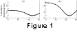 Dependence of the latitudinal steps of integration on geomagnetic
latitude in the sphere and tube is shown in Figure 1 (Figures 1b
and 1a, respectively). It can be seen in the figure that the maximum
of the net convergence (the step minimum) falls at a geomagnetic
latitude of 70o. Figure 1 shows also the latitudinal knots of the
net for all computations.
Dependence of the latitudinal steps of integration on geomagnetic
latitude in the sphere and tube is shown in Figure 1 (Figures 1b
and 1a, respectively). It can be seen in the figure that the maximum
of the net convergence (the step minimum) falls at a geomagnetic
latitude of 70o. Figure 1 shows also the latitudinal knots of the
net for all computations.
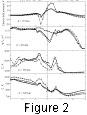 The computations were performed for the time intervals of 0000-0624
UT on March 24, 1987, with the same values of the model input
parameters (the solar radiation flux, flux of the precipitating
electrons, and field-aligned currents) as in the papers by
A. A. Namgaladze et al.
[1993a, 1993b, 1994] for quiet conditions. The results
for 0624 UT and all three versions of the net are presented in
Figures 2 and 3, where the computed latitudinal variations of the
parameters of the northern hemisphere ionosphere and thermosphere
are shown along the geomagnetic meridians of
210oand 30o, which
correspond to the local time at the magnetic equator of 1546 LT and
0346 LT, respectively. The computed values in the net knots are
shown by the open circles and the dashed line for the rough net,
by the solid circles for the fine net, and by the points
connected by the solid line for the inhomogeneous net.
The computations were performed for the time intervals of 0000-0624
UT on March 24, 1987, with the same values of the model input
parameters (the solar radiation flux, flux of the precipitating
electrons, and field-aligned currents) as in the papers by
A. A. Namgaladze et al.
[1993a, 1993b, 1994] for quiet conditions. The results
for 0624 UT and all three versions of the net are presented in
Figures 2 and 3, where the computed latitudinal variations of the
parameters of the northern hemisphere ionosphere and thermosphere
are shown along the geomagnetic meridians of
210oand 30o, which
correspond to the local time at the magnetic equator of 1546 LT and
0346 LT, respectively. The computed values in the net knots are
shown by the open circles and the dashed line for the rough net,
by the solid circles for the fine net, and by the points
connected by the solid line for the inhomogeneous net.
 In the top part of Figure 2 the computed latitudinal variations are
presented for the electric field potential at an altitude of 175 km,
above which the plasma is believed to be magnetized and the
geomagnetic field lines are believed to be electrically
equipotential. In the other parts of Figure 2 (from top to bottom)
the computed latitudinal variations of the parameters of the
ionospheric
F2
region at 300 km are presented: logarithm of the
electron concentration, electron temperature, and ion temperature.
Figure 3 shows
the computed latitudinal variations of the thermospheric parameters
at 300 km (from top to bottom): temperature, logarithm of the atomic
oxygen concentration, and the magnitude of the vector of the
thermospheric wind horizontal velocity.
In the top part of Figure 2 the computed latitudinal variations are
presented for the electric field potential at an altitude of 175 km,
above which the plasma is believed to be magnetized and the
geomagnetic field lines are believed to be electrically
equipotential. In the other parts of Figure 2 (from top to bottom)
the computed latitudinal variations of the parameters of the
ionospheric
F2
region at 300 km are presented: logarithm of the
electron concentration, electron temperature, and ion temperature.
Figure 3 shows
the computed latitudinal variations of the thermospheric parameters
at 300 km (from top to bottom): temperature, logarithm of the atomic
oxygen concentration, and the magnitude of the vector of the
thermospheric wind horizontal velocity.
Discussion and Conclusions
Figures 2 and 3 demonstrate that the strongest difference between
the computed results for the rough and fine nets takes place in
the values of the electric field potential and parameters of the
ionospheric
F2
region at high latitudes (above geomagnetic latitude
of 60o). For example, the voltage across the polar cap in the
rough net is 47 kV, and in the fine one it is only 18 kV (the top
part of Figure 2) under the same values of the field-aligned
currents, which are used as input parameters at the polar cap
boundaries (geomagnetic latitude of 75o). The difference is due to
the fact that the field-aligned currents decrease from their maximum
value to zero at the distance of one latitudinal step of
integration. This difference is 5o and 2o in the rough and
fine nets, respectively (the width of the field-aligned current
zone being less than the latitudinal step in the rough net); as a
result, smaller electric charge is put into the ionosphere and the
electric field value drops, respectively.
Owing to the reduced convection in the fine net, plasma transport is
practically absent from the dayside through the pole to the
nightside, which forms a so-called ionization "tongue." As a result,
the electron concentrations in the near-pole
F2
region are
significantly lower in the fine net than in the rough one, and
the electron temperatures are respectively higher (Figure 2). The
ion temperature in the fine net is lower than in the rough one
because Joule heating.
The differences in the thermospheric parameters (Figure 3) computed
for the rough and fine nets are not concentrated only at high
latitudes but are more or less homogeneously distributed around the
globe. This is due to the fact that the horizontal transport of the
charged components of the
F2
region is important mainly at high
latitudes, whereas the transport of the neutral thermospheric gas is
equally important everywhere. The amplitude of the temperature
variations at 300 km in computations with the fine net is 80 K
less than that with the rough one. Correspondingly, the amplitude of
the latitudinal variation of the atomic oxygen concentration and
total density is less in the fine net. Lower horizontal gradients
of the temperature lead to lower velocities of the horizontal winds.
It is also worth noting the smoother latitudinal variations computed
with the fine net compared to the rough one.
Thus, using the rough nets with the latitudinal integration steps
exceeding
2o
also leads, besides limitations related to the
field-aligned currents and precipitations, to overestimation of
the calculated electric fields and, accordingly, of the effects
generated by them at high latitudes. Usage of the rough nets to
investigate midlatitude phenomena is quite reasonable owing to their
practicality.
Let us consider now the computations performed with the
inhomogeneous net with variable (depending on latitude) step of the
numerical integration of the model equation. Figure 1 shows that the
inhomogeneous net is close to the fine one at geomagnetic
latitudes above
60o
and to the rough one at latitudes below 30o.
The comparison of the model simulations for all three versions of
the net is presented in Figures 2 and 3 and visually demonstrates
that using the inhomogeneous net produces results for the majority
of parameters close to those obtained with the fine net not only
at high latitudes, but all around the globe.
It is essential that noticeable savings of computer resources is
achieved without significant loss in accuracy. This fact allows
performance of the model simulations at personal computers of the
moderate class of the PC AT486 DX2 50, 66 type. On the whole,
transition to the inhomogeneous net with variable integration step
provides the following gains in comparison with the 2-degree
(fine) net: about 3 times by the computation rate (and by 6 times
if the temporal integration step is increased from 1 to 2 min), from
31 to 16 Mb in disk memory for the operating file of the model and
from 7 to 3.8 Mb for saving the snapshot of the calculated parameter
distribution, and from 14 to 7.6 Mb in on-line memory. As far as the
stability of the computations is preserved, these facts demonstrate
a high efficiency of the developed algorithms, which allow
convergence of the net in the places where higher spatial resolution
of the model is required.
Acknowledgments
This work was supported by the Russian Foundation
for Basic Research (project 94-05-17321) and the International Science
Foundation (project RLX 000).
References
Barbolina, E. V., V. V. Kachala, O. V. Martynenko, and
A. N. Namgaladze, Global modeling of geophysical processes at a personal
computer (the GLOMO complex), Preprint PGI-93-01-93,
28 pp., Polar Geophys. Inst., Apatity, 1993.
Korenkov, Yu. N., et al.,
Comparison of global description of the ionospheric parameters in
the theoretical and empirical ionospheric models, in
Polar Ionosphere Studies, p. 16, PGI AN SSSR, Apatity, 1990.
Korenkov, Yu. N., et al., Model
calculations of the ionospheric parameters for March 19, 1988,
Geomagn. Aeron., 33 (1), 63, 1993.
Namgaladze, A. A., et al., Global
model of the thermosphere-ionosphere-protonosphere system,
Pure Appl. Geophys., 127 (2/3), 1988.
Namgaladze, A. A., et al., Global
numerical model of the terrestrial thermosphere, ionosphere and
protonosphere, Geomagn. Aeron., 30 (4), 612, 1990.
Namgaladze, A. A., et al.,
Numerical modeling of the thermosphere-ionosphere-protonosphere
system, J. Atmos. Terr. Phys., 53 (11/12), 1113, 1991.
Namgaladze, A. A., M. A. Volkov, M. A. Martynenko, and A. N.
Namgaladze, Numerical simulation of high-latitude effects of a
substorm (abstract),
in Mathematical Models of the Near Space,
p. 39, NIIYaF MGU, Moscow, 1993a.
Namgaladze, A. A., et al.,
Numerical simulation of the ionospheric disturbance over EISCAT by
the use of the global ionospheric model, in
Sixth EISCAT Workshop, Andenes, Book of Abstracts, p. 17, 1993b.
Namgaladze, A. A., O. V. Martynenko, A. N. Namgaladze, and M. A.
Volkov, Numerical simulation of the main ionospheric rough dynamics during
the March 25, 1987 substorm, in Physics of the Auroral Phenomena,
Preprint PGI-94-01-96, 22 pp., Polar Geophys. Inst., Apatity, 1994.
Namgaladze, A. N., O. V. Martynenko, V. V. Kachala, and E. V.
Barbolina, Realization of the global numerical model of the
terrestrial thermosphere, ionosphere and protonosphere at a personal
computer (abstracts), in
Mathematical Models of the Near Space,
p. 82, NIIYaF MGU, Moscow, 1993.
Load file for printing and local use.
This document was generated by TeXWeb (Win32, v.1.0) on December 12, 1997.